Chronotrains
Chronotrains offers an interactive map visualizing train travel times across Europe, showcasing distances from major cities and highlighting eco-friendly and efficient transportation options.
Exploring Europe by Train: An Interactive Map for Travelers
The Chronotrains interactive map offers a smart way to visualize train travel across Europe. Designed with the eco-conscious traveler in mind, it promotes sustainable transportation options while allowing users to plan their journeys effectively.
Key Features
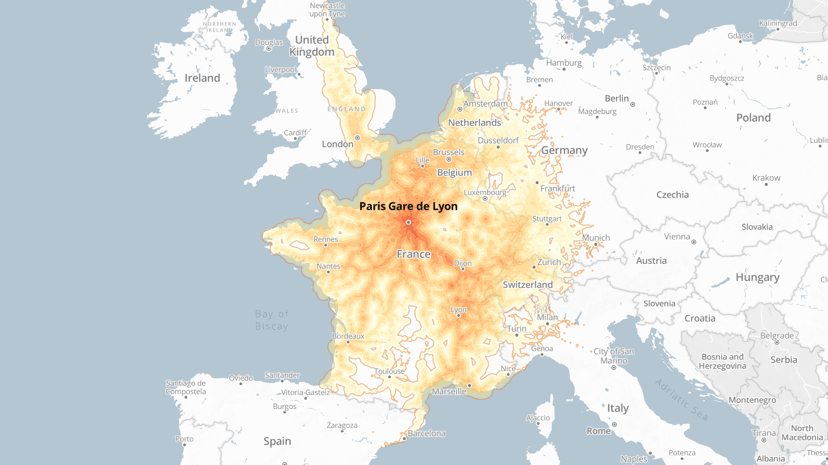
One of the standout elements of the Chronotrains map is its user-friendly interface that allows travelers to explore connections between major European cities within a maximum travel time of eight hours. The map integrates estimated travel times from Deutsche Bahn, providing accurate insights into how far one can reach from any given station. Travelers can hover over the map to view isochrones, which visually represent areas accessible within specified timeframes.
The map supports planning multi-city trips, making it an ideal tool for those seeking to efficiently visit multiple destinations. Onboard amenities, spacious seating, and the freedom to move about create a comfortable travel experience, eliminating the usual hassle associated with longer journeys.
Target Audience
Chronotrains caters to a diverse audience: weekend explorers looking for quick getaways, long-term travelers planning extensive itineraries, and anyone seeking an efficient alternative to road travel. Frequent commuters and students can also benefit from understanding the best connections available to maximize their travel budgets.
Benefits and Uniqueness
Using the Chronotrains map allows travelers to find the best routes, reducing travel time significantly compared to other modes of transport. As a sustainable option, train travel helps lower carbon footprints while providing a scenic view of Europe’s captivating landscapes.
Furthermore, the map includes links to service websites for users to discover the latest offers and book their journeys conveniently.
In summary, the Chronotrains interactive map is a practical tool for those wishing to explore Europe’s rich cultural tapestry through a stress-free and environmentally friendly approach. Its emphasis on both efficiency and comfort enhances the overall travel experience, making it easier than ever to create memorable journeys across the continent.